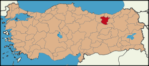
Gümüşhane Province
Gümüşhane Province is a province in northern Turkey, bordering Bayburt to the east, Trabzon to the north, Giresun and Erzincan to the west. It covers an area of 6,575 km² and has a population of 191,474 in 2006. The population was 186,953 in 2000. The name Gümüşhane means silver house. The city has a rich mining (silver and bronze) history and was the source of exports for Trabzon. The ancient Greek name of the city was Θήρα (Thera) meaning, gate or doorway.
Geography
Gümüşhane is surrounded by high mountains, Zigana-Trabzon Mountains to the north, Çimen Mountains to the south, Giresun Mountains to the west and Pulur, Soğanlı Mountains to the east. Trekking is popular sport is at these mountains. The Zigana Mountain has a ski center on it and it is a well known touristic place for winter sports. Abdal Musa Peak (3331 m.) is the highest peak within it. The main trees in the forests are Scotch pine and fir, and there are many animals and birds in the area. There are many lakes such as Karanlık Göl, Beş Göller, Artebel Gölü, Kara Göller which are at the peak of Gavurdağı Mountain, and are preserved as natural parks. These all mountains compose 56% of the area of Gümüşhane province.
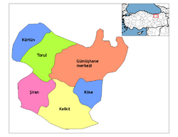
Districts
Gümüşhane province is divided into 6 districts (capital district in bold):
- Gümüşhane
- Kelkit
- Köse
- Kürtün
- Şiran
- Torul
See also
- 2009 Zigana avalanche
- Zigana Pass
External links